June 15, 2021, Vancouver, Canada – Jaxon Mining Inc. (“Jaxon” or the “Company”) (TSX.V: JAX, FSE: OU31, OTC: JXMNF) announces that the field team, led by Dr. Tony Guo, has kicked off the 2021 field season and is now preparing for the Phase One drilling program at Netalzul Mt. Field work includes structural mapping, as well as soil and rock sampling and mapping at Netalzul Mt. Drill testing the high-grade silver polymetallic veins and porphyry systems at Netalzul is scheduled to commence early July. Drill testing the porphyry systems at Red Springs is scheduled for the fall of 2021.
Fathom Geophysics Reports
The Company is pleased to announce it has received two studies on the Netalzul Mt and Red Springs projects prepared by Fathom Geophysics of Ohio, USA fathomgeophysics.com. “3D Porphyry Footprint Modeling of Netalzul, British Columbia, Jaxon Mining, May 2021” and “3D Porphyry Footprint Modeling of Red Springs British Columbia, Jaxon Mining, May 2021” by Dan Core, Fathom Geophysics. The studies were commissioned to assist the Company in its target/site modeling exercise at Netalzul Mt and to advance its ongoing conceptual geological modelling, target visualization and vectoring programs at the Hazelton property.
The studies indicate that the porphyry systems at Netalzul Mt and Red Springs are associated with uniquely and anomalously high mineralization levels across the spectrum of porphyry associated metals, in assayed soil and rock samples.
The Netalzul study identified three major porphyry targets by comparing the structural, geochemical, and geophysical features of the Netalzul Mt porphyry system to reference models of other known porphyry systems. The 2021 drilling targets at Netalzul involve a system of copper-molybdenum porphyries with related intermediate sulfidation (IS) type high-grade silver polymetallic deposits. Outcrops containing anomalously high-grade material were sampled, assayed and reported on during the field exploration programs conducted in 2019 and 2020. Both the Netalzul and Red Springs studies produced confirmatory information correlating with the Company’s field work, geological modeling and the originally sited drilling targets. The porphyry footprint modelling effectively locates, visualizes and vectors in on the targets.
The principal motivation for commissioning the studies was to take advantage of an independently produced, model-driven approach to targeting porphyries and their associated mineralization. This process provided an expert review of the entirety of the Company’s geochemical and geophysical data, in combination with structural mapping and the other datasets.
The Netalzul study includes the compilation, processing and modelling of both soil and rock geochemical datasets and newly acquired aeromagnetic data. The study involves a live evolving model that will continue to be updated with new information, including information from drill core and cuttings. To date, the information in the study has allowed the Company to visualize, better locate and more precisely vector in on the location of the porphyries and to better locate the distal intermediated sulfidation high-grade copper silver polymetallic mineralized vein systems associated with the porphyry systems at Netalzul Mt. Further sampling work will be completed, as recommended. Additional work around the results of the Red Springs study will be conducted later in the summer of 2021 prior to commencing the Phase 2 drilling program.
Highlights of the Netalzul study include:
- Five potential targets were defined by applying the footprint modeling method to the Netalzul soil and rock data (Table 1, Figures 1-4). Four of these five targets, FG-NZ-Soils-1 and 2, FG-NZ-Rocks-1 and 2, will be drill tested in Phase One of the 2021 drilling program (Figure 6). The 3D footprint models indicate that the FG-NZ-Soils-1, FG-NZ-Rocks-1 and FG-NZ-Rocks 2 targets all have the potential for deep mineralization, down to 800-1200 meters in depth.
- Geophysical signatures of the porphyry mineralization are recognized as discrete magnetic lows or magnetic highs. Four potential porphyry Cu-Mo or other mineralization centers were identified. Two are magnetic highs and two are magnetic lows; these could be the porphyry centers depending on which part of the porphyry is exposed (Figure 5). Three of these porphyry centers will be drill tested in the 2021 Phase One drilling program (Figure 5). Porphyry mineralization showings previously observed are within or near these porphyry targets defined by the Netalzul study.
- Ring structures in the northwestern corner of the magnetic anomaly are considered a caldera collapse (Figure 6) with the potential to be a low-grade bulk tonnage epithermal Ag-Au deposit, based on both rock and soil sampling in 2020 and 2021.
Mr. John King Burns, CEO and Chairman of Jaxon Mining, commented, “To develop sophisticated geological models of the Netalzul Mt and Red Springs projects, our team has integrated the use of advanced geochemical and geophysical methods as exploration tools in combination with structural mapping work. Dr. Guo has organized and is conducting a world class, multi-disciplinary exploration program in pursuit of multiple targets, each with the scope, scale and features necessary to become a commercial copper (polymetallic) mine.”
“We are applying all appropriate tools to help us build better and more accurate models of our targets, and we will continue to conduct comprehensive and disciplined exploration as we develop those targets. Our approach reduces drilling risks and expenses and allows for improved drilling results. This systematic and interdisciplinary approach takes time but allows us to delineate and create well-developed and more accurate pictures of our targets before commencing drill testing. Fathom’s work indicates the porphyries are there and should be pregnant with metal. We are looking forward to the 2021 drill programs demonstrating that.”
Table 1: Targets highlighted by the footprint modeling method applied to the Netalzul soil and rock data.

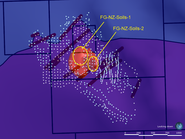
Figure 1: Netalzul_Soils_Halley_90th_3D Targeting Results Plan View – Soils Well-constrained at Netalzul Mt. project (The image above shows the 0.18 isosurface of the results for the soil data using a model built using the Halley model geometry with thresholds generated using the 90th percentile of the soil data. The results are masked to show only well-constrained targets. The central part of the survey is highlighted as a high-ranking target. The target is split into a shallow and deep part. Results could be improved if the gaps in the soil survey were filled.)
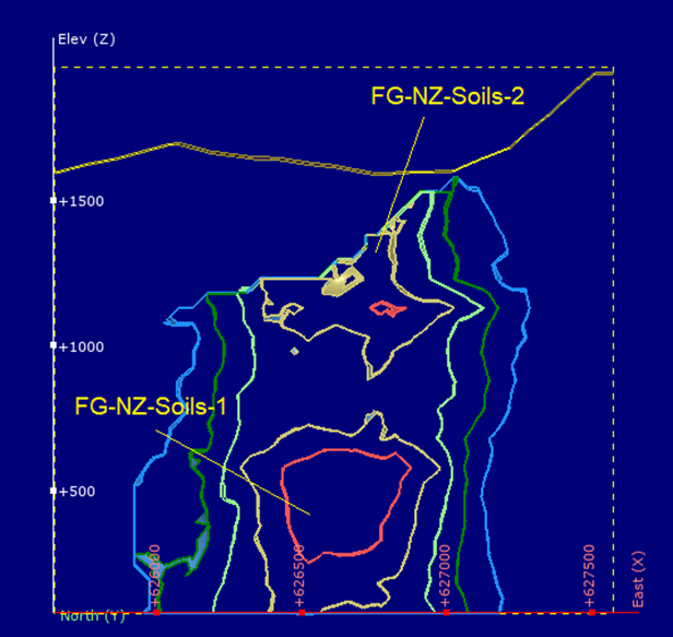
Figure 2. Netalzul_Soils_Halley_90th_Const_3D Targeting Results Section View – Soils well-constrained (The image above shows a cross section through the well-constrained soil processing results. The section is from 626050E 6128675N on the left to 627225E 6130075N on the right. The near-surface part of the target area is less well-constrained because the deeper part of the model is narrower.)
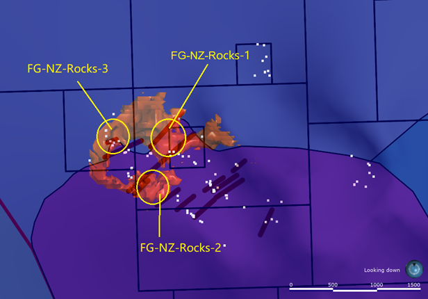
Figure 3. Netalzul_Rocks_Halley_Const_3D Targeting Results Plan View – Rocks well-constrained (The image above shows the 0.85 isosurface of the results for the rock samples using the Halley model. The results are masked to show the better constrained parts of the results. FG-NZ-Rocks-1 is a relatively vertically extensive target and scores very highly. Additional rock chip sampling would be necessary to determine if the best target location is more likely at FG-NZ-Rocks-1 or FG-NZ-Soils-1.
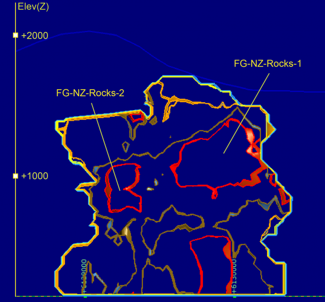
Figure 4. Netalzul_Rocks_Halley_Const_3DTargeting Results Section View – Rocks well-constrained (The image above shows a cross section through the well-constrained rock processing results. The section is from 626075E 6128800N on the left to 626675E 6130690N on the right. Masking to the more well-constrained areas reduces some of the noise. Additional sampling would help further constrain the targets.)
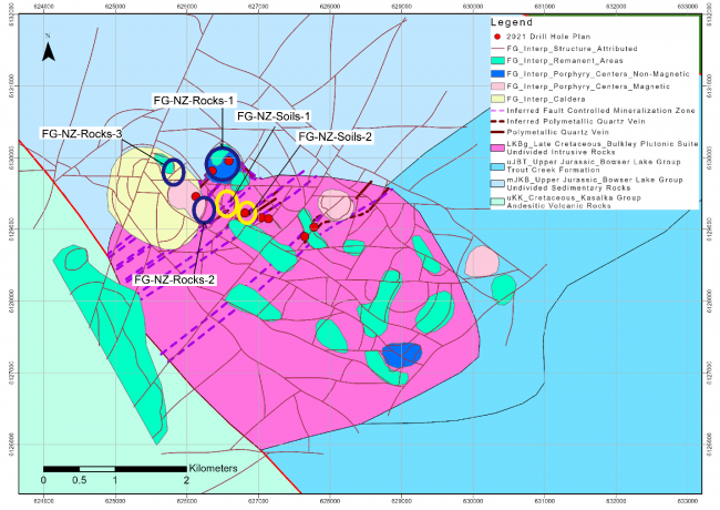
Figure 5. Jaxon’s 2021 planned drill hole locations and Dr. Core’s geochemical footprint model targets and aeromagnetic data interpretation image map.
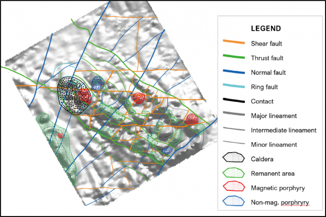
Figure 6. Structural and Magnetic Anomalies Interpretation Image Map at Netalzul Mt. project(Structural, mineralization and magnetic anomalies interpreted from the magnetic data over the Netalzul area, as indicated in the legend).
Qualified Person
Yingting (Tony) Guo, P.Geo., President and Chief Geologist of Jaxon Mining Inc., a Qualified Person as defined by National Instrument 43-101, has reviewed, and prepared the scientific and technical information and verified the data supporting such scientific and technical information contained in this news release.
About Fathom Geophysics
Fathom Geophysics provides geophysical and geoscience data processing and targeting services to the minerals and petroleum exploration industries, from the regional scale through to the near-mine deposit scale. Among the data types we work on are: potential field data (gravity and magnetics), electrical data (induced polarization and electromagnetics), topographic data, seismic data, geochemical data, precipitation and lake-level time-lapse environmental data, and remotely-sensed (satellite) data such as Landsat and ASTER.
Fathom Geophysics offers automated data processing, automated exploration targeting, and the ability to tailor-make data processing applications. Fathom Geophysics’ automated processing is augmented by expert geoscience knowledge drawn from in-house staff and from details relayed to us by the project client. Fathom Geophysics also offers standard geophysical data filtering, manual geological interpretations, and a range of other exploration campaign-related services, such as arranging surveys and looking after survey-data quality control.
About Jaxon Mining Inc.
Jaxon Mining is a Canadian-based exploration and development company pursuing the discoveries of commercial scale and grade Cu, Au, Ag, polymetallic projects. Jaxon focuses on overlooked and underexplored targets with deeper intervals that have not been identified or adequately explored; in areas that often have not been systematically mapped, modeled or drilled. Jaxon is currently focused on the Skeena Arch, an exceptionally orogenic and metallogenic area, in one of the most richly endowed terrains in British Columbia. The Company is preparing its 2021 drilling program to test the Netalzul Mountain and Red Springs projects on its 100% controlled Hazelton property.
ON BEHALF OF THE BOARD OF DIRECTORS
JAXON MINING INC.
“John King Burns”
John King Burns, Chairman
For more information please contact:
Investor Relations
Kaye Wynn Consulting
T: 604-558-2630
TF: 1-888-280-8128
E: info@kayewynn.com
Freeform Communications
T: 604-243-0499
E: enquiries@freeform.com
Corporate
T: 604-424-4488
E: info@jaxonmining.com
This news release may contain forward-looking information, which is not comprised of historical facts. Forward-looking information involves risks, uncertainties and other factors that could cause actual events, results, performance, prospects and opportunities to differ materially from those expressed or implied by such forward-looking information. Forward-looking information in this news release may include, but is not limited to, the Company’s objectives, goals or future plans. Factors that could cause actual results to differ materially from such forward-looking information include, but are not limited to, those risks set out in the Company’s public documents filed on SEDAR. Although the Company believes that the assumptions and factors used in preparing the forward-looking information in this news release are reasonable, undue reliance should not be placed on such information, which only applies as of the date of this news release, and no assurance can be given that such events will occur in the disclosed time frames, or at all. The Company disclaims any intention or obligation to update or revise any forward-looking information, whether as a result of new information, future events or otherwise, other than as required by law. Neither TSX Venture exchange nor its Regulations Services Provider (as that term is defined in the policies of the TSX Venture Exchange) accepts responsibility for the adequacy or accuracy of this release.
