January 19, 2022, Vancouver, Canada – Jaxon Mining Inc. (“Jaxon” or the “Company”) (TSX.V: JAX, FSE: 0U31, OTC: JXMNF) is pleased to announce it has extended the soil and rock sampling program at the Netalzul Mt project where 120 rock and 409 soil samples were collected from the new areas in the 2021 field season (Figure 1). The samples report up to 3052 g/t silver equivalent including 2915 g/t Ag, 0.39 g/t Au, 0.35% Cu, 2.06% Pb and 0.43% Sb (Table 1). Based on MDRU’s Toodoggone report (link), the samples identify a high MPIx (MDRU Porphyry Index) centre area coincident with the target vectors generated by Fathom Geophysics’ previous modeling. These surface expressions are a product of the large epithermal porphyry system Jaxon is targeting within Netazul Mt.
38 of the new rock samples were assayed for porphyry geochemical index elements and the results outline a high MPIx centre which is used to vector in on the location of the centre of the porphyry system. The Netalzul Mt porphyry is marked by geochemical anomalies involving an intense suite of indicator minerals, as well as significant geophysical anomalies, structural controls and an extended propylitic alternation zone populated with multiple, polymetallic high-grade epithermal, sulfide quartz veined zones perforated by monzonite dykes and with visible K-silicate alteration. Jaxon has commenced programming to conduct a definitive drill test of the centre and the mineralized shells of the Netalzul Mt porphyry system in the summer of 2022.
Netalzul Mt is one of seven porphyry system targets on Jaxon’s 100% owned Hazelton property in northwestern British Columbia, approximately 50 km north of the town of Smithers.
Highlights of 2021 Rock and Soil Sampling at Netalzul Mt Project
- 409 soil samples were collected and tested in the field with a handheld XRF analyzer. A large strong Zn anomaly (up to 3681 ppm; 11.7% of soil samples >1000 ppm) was identified in the strongly faulted hornfels area to the north boundary of the Netalzul granodiorite intrusion (Figure 2). The Zn anomaly overlays the Rocks 1 geochemical anomaly previously defined by Fathom Geophysics in early 2021 (news release), and coincides with a discrete demagnetized zone, comparable to the Blackwater deposit in the same geological setting 250 km southeast of the Netalzul Mt project.
- 38 of the 2021 rock samples were assayed for 48 elements to extend the geochemical survey area. Jaxon applied MDRU’s MPIx to characterize the samples as porphyry/proximal, distinguishing them from those typically found in distal/shallow mineralizing environments. A higher MPIx number indicates closer proximity to porphyry-type mineralization. The Netalzul rock samples with the higher MPIx indexes are concentrated in the area surrounding Pad 5 (Figure 3). These results are consistent with the results generated by Fathom Geophysics’ modeling of Jaxon’s geochemical and geophysical data in 2021, as well as with the lithology and mineralization observed in the core logs (strong potassic quartz veins and alterations), the assay results from the 2021 drilling program, the field observations of K-silicate alteration, and the observations in the core of the multiple occurrences of monzonite dykes.
- 82 mineralized rock samples were collected and assayed for 34 elements. Two new artisanal mining adits (Adit 3 and Adit 4) were discovered in the east extension of the Daisy South Adit Zone (Figures 1, 5 and Table 1). Ag grades can be up to 2915 g/t with 0.39 g/t Au, 0.35% Cu, 2.06% Pb and 0.43% Sb from a one metre chip outcrop sample (sample ID# 72013) at the Adit 4 area within the Daisy South Adit Zone (Figure 5); Au grades can be up to 7.01 g/t with 49 g/t Ag and 0.53% Cu from a one metre quartz vein zone chip outcrop sample (sample ID# A0027300) at Daisy North Contact Zone (Figure 6); Cu grades can be up to 1.47% with 20 g/t Ag from a porphyry monzonite dyke outcrop grab sample (sample ID# 72521) at the southwest area of Netalzul Mt project (Figure 7). These rock samples have typical epithermal intermediate sulfidation (IS) mineralization or display the disseminated porphyry characteristics generated by deep porphyry systems as prototypically modeled (Figure 8).
Statement from Chairman and CEO John King Burns
“Netalzul Mt exhibits one of the strongest geochemical anomalies indicating the location of a porphyry system in BC to date and was ranked as Jaxon’s priority porphyry target, the first of seven on the Hazelton property, using Fathom Geophysics’ comparative porphyry model earlier in 2021.”
“Jaxon’s primary technical focus in the winter of 2022 is to reprocess all existing geochemical and geophysical datasets, integrate the new data collected in 2021 and regenerate our geological models to show the geometry of and generate more precise locational coordinates for the Netalzul Mt porphyry system. The modelling will be reviewed by Jaxon’s geochemical, geophysical and structural advisors as part of a comprehensive drill target vectoring exercise.”
“In the spring of 2022, we expect to publish the updated 3D geological model illustrating projections of the Netalzul Mt porphyry system and the specific vectors that each of the ~5 planned, ~1200-metre tests holes will follow.”
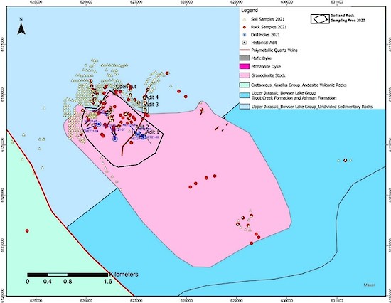
Figure 1. Soil and rock samples, Netalzul Mt, 2021
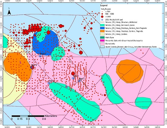
Figure 2. A large and strong Zn anomaly (> 1000 ppm) has been identified in the hornfels at Netalzul Mt.
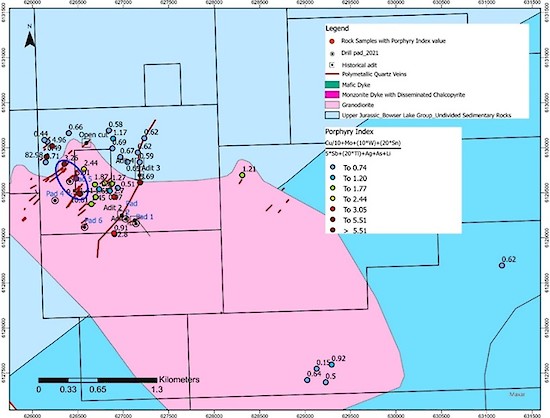
Figure 3. MDRU Porphyry Index ratios indicating the footprint of the porphyry mineralization at Netalzul Mt.
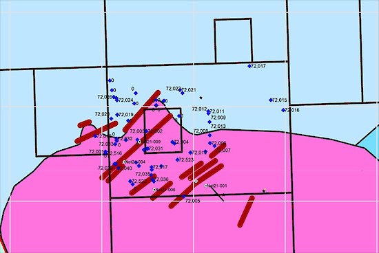
Figure 4. Rock samples (represented by blue diamonds) from mineralized zones at Netalzul Mt.
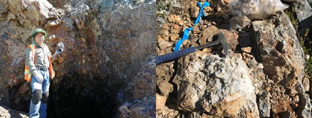
Figure 5. Adit 3 (left); one metre chip sample (#72013) from Adit 4 area with Ag grade @ 2915 g/t (right).
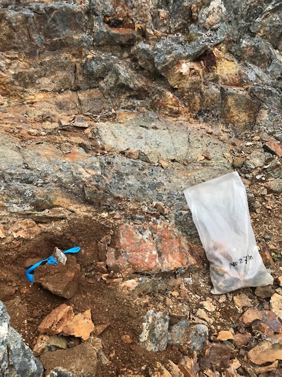
Figure 6. One metre chip sample (A0027300) at Daisy North Contact Zone area with Au grades of up to 7 g/t.
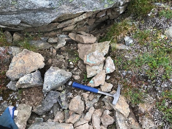
Figure 7. Monzonite dyke grab sample (72521) with Cu grades of up to 1.47% from the southwest area of Netalzul Mt.
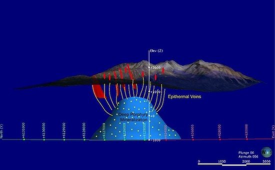
Figure 8. Conceptual model of epithermal-porphyry system at Netalzul Mt.
Table 1. Significant Assay Results from Rock Samples at Netalzul Mt in 2021
| Sample ID | Description | Au ppm | Ag ppm | Cu ppm | Pb ppm | Sb ppm | Zn ppm | AgEq ppm |
| 72013 | Breccia QV with tetrahedrite in adit 4 area | 0.39 | 2915 | 3518 | 20600 | 4252 | 738 | 3052 |
| 72004 | Sulfide QV at Daisy central zone | 1.54 | 1960 | 22750 | 19300 | 10000 | 5768 | 2416 |
| A0027292 | 2 m wide polymetallic QV at Daisy central zone | 0.82 | 442 | 5824 | 41400 | 3336 | 23100 | 725 |
| A0027300 | 4 QVs ~ 10-40cm each, total 3-4m wide at Daisy Central zone | 7.01 | 49.1 | 5301 | 681 | 39 | 1523 | 613 |
| 72008 | 2m wide massive sulfide QV veins at adit 3 area | 0.16 | 298 | 2651 | 33600 | 591 | 7040 | 432 |
| 72035 | Sulfide QV 30cm | 4.41 | 64.7 | 2110 | 1588 | 300 | 315 | 410 |
| 72007 | Strongly oxidized QV, abundant pyrite and chalcopyrite patches | 0.15 | 93 | 28890 | 56 | 8 | 98 | 395 |
| 72015 | QV float with chalco-py. and black minerals. | 0.18 | 234 | 11590 | 1557 | 630 | 569 | 372 |
| 72018 | 50-100cm thick striking 25, dip at 70, str. Py/chalco-py. | 0.70 | 101 | 6242 | 808 | 952 | 1913 | 226 |
| 72009 | Adit 4 area, QV zone >15m | 0.09 | 147 | 683 | 4528 | 587 | 300 | 183 |
| 72521 | disseminate monzonite porphyry dyke under a big granodiorite bold in the SW area | 0.07 | 20.2 | 14710 | 68 | 7 | 152 | 172 |
| 72019 | strongly FeOx altered, 10-15cm wide, ds py | 0.20 | 125 | 1398 | 331 | 167 | 469 | 157 |
| A0027298 | QV and granite in the fracture zone | 0.40 | 92 | 1882 | 842 | 1011 | 2672 | 154 |
| 72041 | QV and Granite with massive chalco-Py and less Py, main QV only 2-3 cm wide | 0.03 | 29 | 11440 | 5 | 5 | 58 | 146 |
| A0027316 | QV float on the east valley slope | 0.15 | 111 | 786 | 1268 | 1685 | 74 | 144 |
| 72006 | Large QV > 50cm in hornfels. it is in contact zone between hornfels and granite, | 0.08 | 63.1 | 1693 | 637 | 615 | 237 | 118 |
| 72002 | 6 QVs, strongly FeOx altered, locally sulphide, largest one 15-20cm wide, others 2-5cm wide | 0.06 | 79.8 | 595 | 162 | 5 | 16 | 93 |
| 72521-1 | monzonite dyke with diss sulfide, extension of Monzonite dyke in hole 5 | 0.03 | 40.4 | 2769 | 207 | 98 | 156 | 91 |
| 72012 | >3m wide QV Breccia zone, QV breccia same as adit 4 | 0.08 | 64.1 | 422 | 484 | 405 | 114 | 80 |
| 72033 | QV and granite, see Mo, Py and gray color Quartz, see yellow Mo oxidation, total QV zone > 20 meters | 0.13 | 40.1 | 1873 | 360 | 58 | 123 | 76 |
| 72010 | QV > 5cm, Py/Chalopy in QV group zone > 2m wide | 0.02 | 39.2 | 2834 | 324 | 16 | 142 | 71 |
Rock and Soil Sampling and Analytical Procedures
All samples described in this news release were collected by the Company’s Qualified Professional Geologists. Chip and prospecting samples were collected in the field by experienced, professional geological staff who selected hand samples from outcrop or chip samples. The samples were numbered, described and located in the field for follow-up. Numbered rock sample tags were placed inside each bag and securely closed for transport to the Company’s secure cold storage locked facility in Smithers, B.C. MSALABS in Langley, B.C. received the rice bag shipments after secure transport from Smithers. Samples were prepared by crushing, grinding and pulverizing to a pulp with barren material washing between each sample at the crush and pulverizing stages. Then 20 g of pulp was used for the ICP-230 for 34 elements or IMS-231 for 48 elements, FAS-111 fire assay for gold with ICP-ES finish and MET-440 for ore grade samples. Overlimit silver is determined by Fire ASSAY 415 method. Laboratory standards and QA – QC are monitored by the Company.
Soil samples were taken on a 50 m by 50 m grid along the mineralization zone. Approximately 200 g to 300 g of soil was sampled at a depth of approximately 25-30 cm from surface. Soil sampling primarily targeted the B horizon where appropriate, and samples were collected in labelled craft paper bags. Soil samples were analyzed via PXRF (Portable Thermo Scientific Niton XL3t GOLDD+ X-Ray Fluorescence Analyzer) for Cu, Pb, Zn, Ag, Mo, Sb and W. All work was conducted by the Company’s team of qualified geologists.
Qualified Person
Yingting (Tony) Guo, P.Geo., President and Chief Geologist of Jaxon Mining Inc., a Qualified Person as defined by National Instrument 43-101, has reviewed and prepared the scientific and technical information and verified the data supporting such scientific and technical information contained in this news release.
About Jaxon Mining Inc.
Rich in large-scale geological targets/assets, Jaxon has seven porphyry system targets on its 100% controlled Hazelton property, an interconnected network of concessions spanning 705.7 km2 in the Toodoggone region of the Skeena Arch in northwest British Columbia, Canada. The Skeena Arch is an exceptionally orogenic and metallogenic setting, geochronologically suitable to host preserved porphyries.
Jaxon pursues the discoveries of deeper, under cover, commercial scale and grade Cu, Au, Ag, polymetallic porphyry epithermal systems associated with distal mineralized, propylitically altered zones nearer to surface. Jaxon’s team is made up of experienced model-driven explorationists. Geochemical, geophysical and structural data is collected and integrated to generate 3D models to assist in the visualization and projection of the location of targeted porphyry systems.
Netalzul Mt is Jaxon’s most advanced target, the priority of seven identified porphyry epithermal system targets at Hazelton. Red Springs is the second target being prepared for drill testing. The five other targets are in various advancing stages of exploration.
ON BEHALF OF THE BOARD OF DIRECTORS
JAXON MINING INC.
“John King Burns”
John King Burns, Chairman
For more information please contact:
Investor Relations
Kaye Wynn Consulting
T: 604-558-2630
TF: 1-888-280-8128
E: info@kayewynn.com
