March 2, 2020, Vancouver, Canada – Jaxon Mining Inc. (“Jaxon” or the “Company”) (TSX.V: JAX, FSE: OU31, OTC: JXMNF) is pleased to report the Company has consolidated its land position around the Blunt Mountain AOI and completed its evaluation of available data from previous studies conducted on the area. The information describes the potential for the existence of both a polymetallic sulfidation vein mineralization as well as Cu-Mo porphyry system mineralization. Blunt Mt. is one of four areas of geologic interest identified on the Company’s Hazelton property.
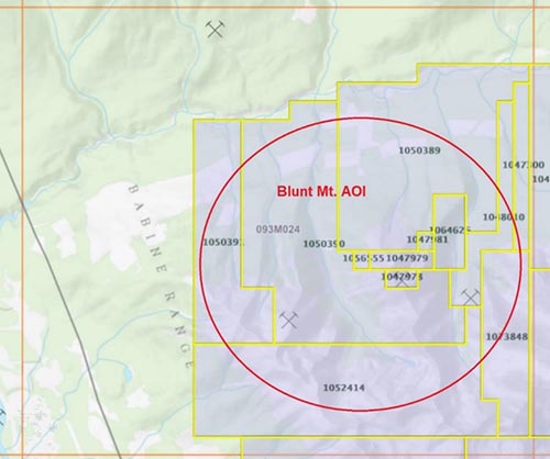
Located at the northwest corner of the Hazelton property, the Blunt Mt. AOI spans 70.62 km2 and consists of 12 claims (Figure 1). A newly consolidated project area, it includes 10 previously held claims, one newly acquired claim (#10646260) and one split claim (#1073848). After reviewing historical prospecting, staking, geological, geophysical and geochemical exploration work and completing a small surficial sampling program in 2017 and 2018, the Company opted to expand and consolidate the Blunt Mt. project area.
Figure 1: Claims map of Blunt Mountain project area (Blunt MT AOI)
The Blunt Mt. AOI lies on a north-western extension of the main Blunt Mountain peak approximately 21 km east of New Hazelton, B.C. and 52 km north of Smithers, B.C. Vehicle access is by a logging road connecting Highway 16 to the property, terminating approximately two km north of the main showing. The property lies within the Intermontane Belt of the Canadian Cordillera. The Skeena Arch, a broad structural high trending north-easterly, underlies the area.
From the mid 1980s through the early 2000s, sporadic exploration was conducted on the area. A government funded geochemical survey indicated anomalous silver, lead, arsenic and antimony values in the vicinity of Skilokis Creek. The area was then staked and limited prospecting, surficial geochemistry, geological mapping and geophysical surveys with hand trenching were completed. The programs included six diamond drill holes (totalling 378 m).
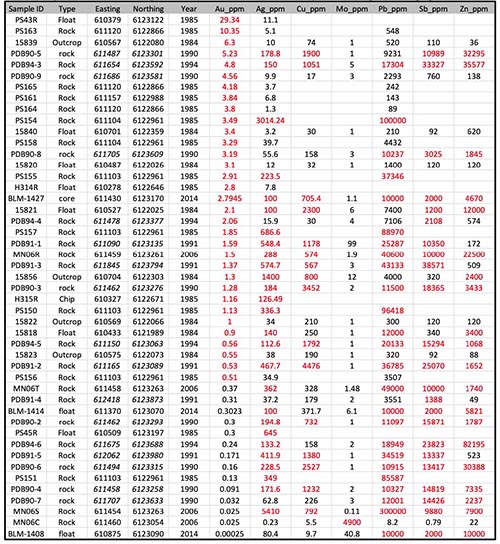
Historical assay results indicate a mineralization corridor along or near the contact zone between the granodiorite intrusive and hornfelsed sedimentary rock with up to 29.34 g/t Au, 5410 g/t Ag, 4478 ppm Cu, 4000 ppm Mo, 10% Pb, 8.2% Zn and 3.8% Sb (Table 1 and Figure 2).
Table 1: Polymetallic element assay results from historical assessment reports show significant high grade results
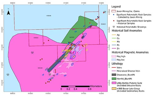
A total of thirteen showings were identified from previous exploration. The showings are either copper-molybdenum porphyries or Ag-Au-Pb-Zn-Sb veins related to various Late Cretaceous Bulkley intrusive, forming a north-easterly trending mineralization corridor approximately 4 km long and 150 metres wide (Figure 2). Within the corridor, veins are occasionally exposed on surface, forming a continuous line or an en echelon system. Veins dip steeply and several veins are exposed by historical trenching over tens of metres. The mineralization is associated with concentrations of galena, sphalerite, pyrite, arsenopyrite and stibnite in quartz and tourmaline veins and associated silicification. Adjacent rocks are altered intrusive or hornfels sedimentary rock.
The granodiorite intrusive is cut by a well-developed set of sheeted joints at an approximate 40 degree strike and is mineralized with amphibole-quartz-magnetite-apatite-sulfide vein. The veins may be zoned and laterally change to predominantly quartz-arsenopyrite-tourmaline vein.
Assay results from 19 outcrop grab and chip samples taken during the 2017 and 2018 field seasons are up to 1886 g/t Ag, 5.45 g/t Au, 2413 ppm Cu, 217 ppm Mo, >1% Pb, >1% Zn and >1% Sb (Table 2). These results confirm the historical assays and existence of a distal Au-Ag-Pb-Zn-Sb sulfide vein mineralization. The historical air magnetic anomalies outline the transition zone between the magnetic high to magnetic low, along the contact zone of Bowser Lake sedimentary rocks and Bulkley Creek intrusive. The developed quartz vein type polymetallic mineralization is overprinted near the contact intrusive and sedimentary rocks, interpreted as potential to host a hidden porphyry type Cu-Mo-Au-Ag mineralization along the magnetic transition belt at the Blunt Mt. AOI.
Table 2: Significant assay results and samples details from Blunt Mt. AOI
| Sample Year | Easting | Northing | Sample Type | Description | Au ppm | Ag ppm | Cu ppm | Mo ppm | Pb ppm | Zn ppm | Sb ppm |
| 2017 | 611117 | 6123060.5 | grab | 50 cm wide qtz vein, strong sericite alteration, semi massive silver s.s., 5% py, exposed for 5m |
5.451 | 60 | 142.4 | 1.58 | >10000 | 421 | 8189.72 |
| 2017 | 611126 | 6123072.4 | grab | 50 cm wide qtz vein, strong sericite alteration, semi massive silver s.s., 5% py, |
3.93 | 619 | 2412.8 | 2.32 | >10000 | >10000 | >10000 |
| 2017 | 611490 | 6123302 | chip | qtz. Msv vein 1.5 m x 5 m exposed brecciated, galena, 10%,splar. 5%, Pyr 10% in diorite, strike 220,dip 60 SE Sample Width 1.50 m |
0.08 | 418 | 1879.5 | 0.29 | >10000 | >10000 | >10000 |
| 2017 | 611702 | 6123636 | chip | brecciated qtz. Msv vein 3 cm x 3m in seds strike 210 / vert. galena.splar. Pyr. Sample Width 3.0 cm |
0.071 | 7.2 | 19.8 | 0.65 | 3909.5 | 1647 | 1302.54 |
| 2017 | 611710 | 6123636 | grab | 5cm x 1 m strlke 200/ dip vert in shale | 0.898 | 5 | 10 | 0.86 | 5295.6 | 402 | 1343.82 |
| 2017 | 611675 | 6123572 | grab | brecciated qtz. Msv vein buried 5-7 m wide fg massive galena.pyr. |
1.552 | 879 | 1382.1 | 5.39 | >10000 | 4479 | >10000 |
| 2017 | 611899 | 6123862 | grab | brecciated qtz. Msv vein 30-50 cm wide fg massive galena.pyr folded , seresite, 220/60 SE |
1.306 | 1886 | 1055.2 | 0.27 | >10000 | >10000 | >10000 |
| 2017 | 611075 | 6123127 | grab | brecciated qtz. Msv vein 10-15 cm wide x 1m 210/vert clay alt on contact with wall rock shale |
3.562 | 994 | 1090.2 | 216.8 | >10000 | 323 | 8265.6 |
| 2017 | 611059 | 6123092 | grab | brecciated qtz. Msv vein 10-15 cm wide x 1m 210/vert clay alt on contact with wall rock shale Sample Width |
4.806 | 131 | 497.1 | 70.51 | >10000 | 320 | 3896.98 |
| 2018 | 611990 | 6118964 | Grab | Granodiorite with 5cm dark green cell of fine grained extrusive? Cpy rims this dark green mass. |
<0.001 | 3 | 150.2 | 1.02 | 2 | 38 | 0.21 |
Figure 2: Outline of compiled geology, historical showings and sample location map of mineralisation corridor at Blunt Mt. AOI
Mr. John King Burns, CEO and Chairman of the Board commented, “The porphyries on our property could potentially be part of the same system and may be related to the same ore-forming processes. This possibility will be examined in the course of future exploration. We believe the 4 km long and up to 150 m wide vein system at Blunt Mt. represents a surface expression generated by a large porphyry intrusive system. Numerous feldspar porphyry dykes were discovered on the property in close proximity to the sulfidation vein mineralization. A large propylitic alteration halo sits in the east part of the area, extending to the east section of the Red Springs porphyry system. This is very interesting and prospective geology in a highly accessible part of British Columbia.”
PDAC 2020 – Toronto
The Company will be represented at PDAC in Toronto. Jaxon will be at booth 3009 with Wildsky Resources from March 1 to March 4, 2020.
Sample Preparation and Analyses
All samples described in the news release were collected by the Company’s Qualified Professional Geologists. Chip and prospecting samples were collected in the field by experienced, professional geological staff who selected hand samples from outcrop or chip samples. The samples were numbered, described and located in the field for follow-up. Numbered rock samples tags were placed inside each bag, securely closed for transport to the Company’s secure cold storage locked facility in Smithers, B.C. MS Analytical of Langley, B.C. received the Rice Bag shipments after secure transport from Smithers. Samples were prepared by crushing, grinding and pulverizing to a pulp with barren material washing between each sample at the crush and pulverizing stages. Then 20 g of pulp was used for the (IMS-117 code) ultra-trace level ICP/MS AR digestion method, and four acid 0.2 g ore grade ICP – AES method (ICP-240) and for the overlimit gold the FAS-415 method of 30 g fusion Gravimetric method was used to report gold ASSAYS. Overlimit silver is determined by Fire ASSAY 415 method. Laboratory standards and QA – QC is monitored by the Company.
Qualified Person
Yingting (Tony) Guo, P.Geo., President and Chief Geologist for Jaxon Mining Inc., a Qualified Person as defined by National Instrument 43-101, has reviewed and prepared the scientific and technical information and verified the data supporting such scientific and technical information contained in this news release.
About Jaxon Mining Inc.
Jaxon is a precious and base metals exploration company with a regional focus on Western Canada. The Company is currently focused on advancing its Red Springs Project in north-central British Columbia.
ON BEHALF OF THE BOARD OF DIRECTORS
JAXON MINING INC.
“John King Burns”
John King Burns, Chairman
For more information please contact:
Investor Relations
Kaye Wynn Consulting
T: 604-558-2630
TF: 1-888-280-8128
E: info@kayewynn.com
Freeform Communications
T: 604-243-0499
E: enquiries@freeformcom.com
Corporate
T: 604-398-5394
E: info@jaxonmining.com
www.jaxonmining.com


