March 10, 2022, Vancouver, Canada – Jaxon Mining Inc. (“Jaxon” or the “Company”) (TSX.V: JAX, FSE: 0U31, OTC: JXMNF) is pleased to announce the results from the 2021 soil and rock sampling program at the Kispiox Mountain project on the Hazelton Property. 54 rock samples and 11 soil samples were collected during the 2021 field season (Figure 1, Table 1). A high-grade sample with up to 29.69% antimony was collected from within an 8-10 metre wide sulfide quartz veined mineralized zone. Three sulfide quartz mineralized zones with antimony have been identified in the area.
The Kispiox Mountain project is one of seven copper, polymetallic, porphyry-epithermal targets Jaxon is advancing on its 100% owned 723 km2 Hazelton property, located in northwest British Columbia, approximately 50 km north of Smithers, BC.
Key Highlights of the 2021 Rock and Soil Sampling Program at Kispiox Mountain Project:
- Three high-grade antimony sulfide quartz mineralization outcrops, KS zone 1, KS zone 2 and KS zone 3, have been identified by rock and soil samples (Table 1, Figure 2).
- A high-grade rock sample (A0027254) with up to 29.69% antimony was collected from an outcrop within an 8-10 m wide sulfide quartz veining mineralized zone (KS zone 1, Figure 3), containing minerals of lead-gray stibnite and yellow valentinite. Four surface weathered outcrop samples (A0027255, A0027282-A0027284) assayed Sb grades from 0.18% to 0.59% (Figure 4, Table 1). The oxidation and weathering of the stibnite minerals on the surface may be responsible for reducing the antimony grade within the surface rock samples.
- 6 metres of chip samples (A0027274-A0027276, Figure 5) from the second sulfide quartz antimony mineralization zone (KS zone 2) reported an average of 2.52% antimony including a 2-metre massive sulfide zone with 6.48% antimony (Table 1, Figure 6) and multiple narrow sulfide antimony quartz veins from 1 centimetre to 20 centimetres over 4 metres.
- Three rock samples (A0027277-A0027279) were collected from KS zone 3 and reported Sb assays from 0.77% to 2.76% (Figure 2, Table 1). These rock samples contain typical striated prismatic stibnite crystals (Figure 7).
- 11 soil samples were collected from between KS zone 1 and KS zone 2 and tested with a handheld XRF analyzer which confirmed a high Sb in soil anomaly within the area (Figure 8).
- 31 rock geochemical samples show elevated Cu, Mo, As and Sb anomalies (Table 2, Figure 9) for porphyry signatures.
Mr. John King Burns, CEO and Chairman of Jaxon, commented,“The rocks with these high-grade antimony results were taken from the propylitic alteration zone at the top of Kispiox Mountain. These anomalously high Sb grades set up the discoveries of a large antimony deposit and of the deeper porphyry system below. We will conduct further systematic soil and sulfide rock outcrop channel sampling programs and additional ground and remote geophysics in the summer of 2022, if time and budgets allow. The elevated Cu, Mo, Pb, Zn and As and the stibnite mineralization in the strong oxide hornfels are classical indicators of a deeper porphyry system. Our target is the porphyry-epithermal system located below Kispiox’s epithermal cap. We are continuously evaluating our integrated geological models, ranking each of our seven porphyry-epithermal targets at Hazelton in terms of size and potential grade. With the current information, Kispiox Mountain porphyry ranks at number four behind the Netalzul Mountain, Red Springs, and Blunt Mountain projects.”
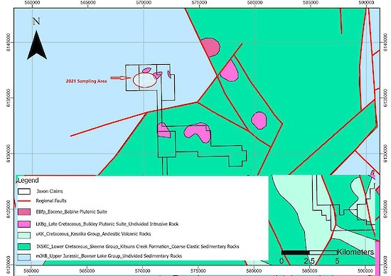
Figure 1. Outline map of geology, mineralization and 2021 sampling area at Kispiox Mountain.
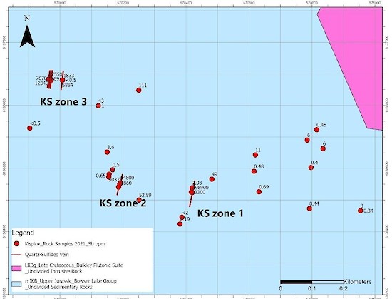
Figure 2. Three Sb sulfide quartz mineralization zones (KS zones 1, 2 and 3) at Kispiox Mountain.
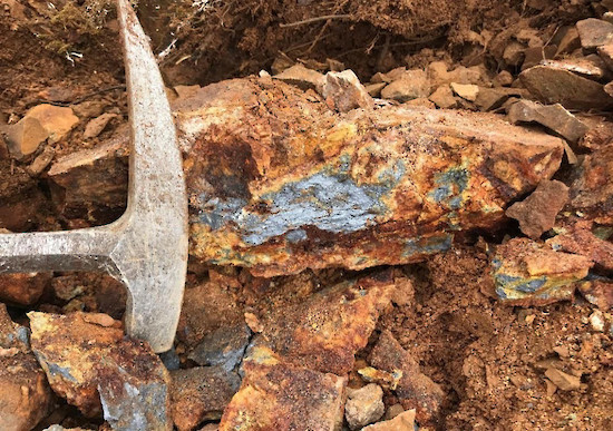
Figure 3. Up to 29.69% Sb rock sample with stibnite and valentinite within 8-10 metre wide KS zone 1.
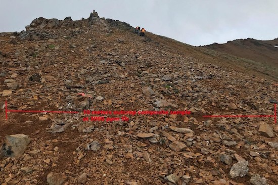
Figure 4. 8-10 metre wide Sb quartz veining mineralization outcrop (KS zone 1).
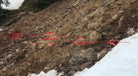
Figure 5. 6 metres of chip samples at KS zone 2 outcrop.
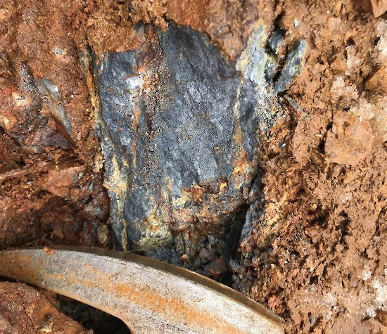
Figure 6. >2 metre-wide massive antimony sulfide (stibnite) at KS zone 2.
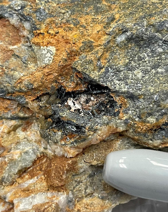
Figure 7. Antimony rock sample with typical striated prismatic stibnite crystals at KS zone 3.
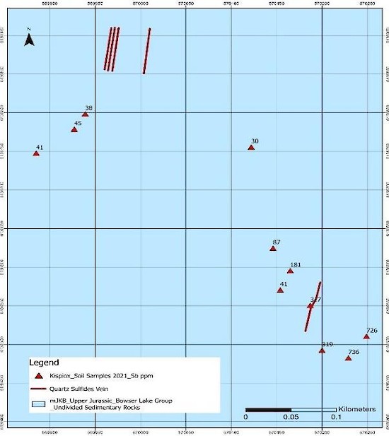
Figure 8. Strong Sb in soil anomalies at Kispiox Mountain.
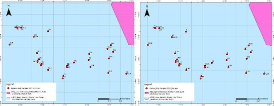
Figure 9. Strong Cu and Mo in rock anomalies at Kispiox Mountain.
Table 1. Significant Rock Sample Assay Results from Kispiox Mountain
| Sample ID | Description | Ag ppm | Au ppm | Cu ppm | Pb ppm | Sb ppm | Zn ppm |
|---|---|---|---|---|---|---|---|
| A0027254 | 10-15 cm wide vein, antimony, stibnite, massive sulfide | 0.7 | 0.02 | 95 | 68 | 296900 | 18 |
| A0027255 | Composite sample, 10 m wide, hornfels with disseminated sulfides, mainly antimony | 1.1 | 0.03 | 94 | 13 | 3300 | 36 |
| A0027274 | Silicified dacite dyke with quartz veins and stibnite veins, 2m chip sample. Str. fractured. The width of stibnite veins varies from 10cm to 0.5 mm. High grade, containing four wide stibnite veins, 10 cm, 3cm, <1cm, <1cm, and many stibnite veinlets | 0.5 | <0.01 | 55 | 41 | 64800 | 70 |
| A0027275 | 2-meter chip sample, containing three stibnite veins, 5 cm, 3cm, <1cm, and many stibnite veinlets | 0.5 | <0.01 | 27 | 12 | 9037 | 37 |
| A0027276 | 2-meter chip sample, containing one wide stibnite veins, 3cm, and many stibnite veinlets | 0.5 | <0.01 | 48 | 13 | 1860 | 75 |
| A0027277 | Four parallel quartz-stibnite veins within 2 m width, Strike: 5°, Azimuth: 95°, Dip: 60~65 °. First vein 15 cm wide, 4-meter west of second vein | <0.5 | <0.005 | 31 | 77 | 27550 | 741 |
| A0027278 | Second vein. 3~5 cm wide, 1.5 m west of third vein | <0.5 | <0.005 | 59 | 52 | 7678 | 114 |
| A0027279 | Chip sample, including third vein and fourth vein. Third vein: 5 cm, Fourth vein: 10~15cm. Vein interval: 1.5 m. | <0.5 | <0.005 | 18 | 19 | 12340 | 55 |
| A0027282 | Sb mineralization zone, 8 m wide composed sample with multiple 10-1 cm quartz-sb veins | 1.1 | 0.02 | 68 | 38 | 1833 | 46 |
| A0027283 | <0.5 | 0.009 | 52 | 8 | 5884 | 38 | |
| A0027284 | <0.5 | 0.022 | 63 | 25 | 1869 | 51 |
Table 2. Rock Geochemical Sample Assay Results at Kispiox Mountain
| Sample ID | Easting | Northing | Ag ppm | As ppm | Au ppm | Cu ppm | Mn ppm | Mo ppm | Pb ppm | Sb ppm | Zn ppm |
|---|---|---|---|---|---|---|---|---|---|---|---|
| 72451 | 570381 | 6136424 | 1.03 | 1.6 | 0.002 | 95.2 | 203 | 7.64 | 15.2 | 2.19 | 19 |
| 72452 | 570420 | 6136539 | 0.06 | 6 | <0.001 | 21.7 | 364 | 34.85 | 2.5 | 2.03 | 45 |
| 72453 | 570616 | 6136591 | <0.05 | 3.7 | <0.001 | 20 | 720 | 1.17 | 2.5 | 0.48 | 78 |
| 72454 | 570632 | 6136526 | <0.05 | 5.2 | <0.001 | 25.4 | 468 | 0.55 | 1.8 | 0.69 | 78 |
| 72455 | 570792 | 6136473 | 0.08 | 1.7 | 0.001 | 28.3 | 471 | 0.93 | 1.5 | 0.44 | 60 |
| 72456 | 570797 | 6136603 | <0.05 | 1.4 | <0.001 | 14.4 | 559 | 0.96 | 2 | 0.4 | 75 |
| 72457 | 570815 | 6136723 | <0.05 | 1 | <0.001 | 18.8 | 296 | 19.63 | 1.9 | 0.48 | 23 |
| 72458 | 569405 | 6136799 | 0.07 | 3.7 | <0.001 | 45.9 | 740 | 1.55 | 3.5 | 0.35 | 102 |
| 72459 | 569413 | 6136891 | 0.09 | 4.9 | <0.001 | 50.4 | 808 | 0.57 | 4.6 | 0.46 | 109 |
| 72461 | 569425 | 6137007 | <0.05 | 3.7 | 0.002 | 8.2 | 989 | 0.61 | 2.3 | 0.86 | 70 |
| 72462 | 569391 | 6137062 | 0.09 | 11.1 | <0.001 | 47.8 | 639 | 1.85 | 3.2 | 4.4 | 91 |
| 72463 | 569282 | 6137015 | 0.08 | 8.5 | <0.001 | 17.1 | 1415 | 0.77 | 4.7 | 0.37 | 80 |
| 72464 | 569262 | 6136913 | 0.05 | 5.3 | <0.001 | 25 | 1190 | 0.98 | 3.8 | 0.89 | 80 |
| 72465 | 570954 | 6136466 | 0.08 | 3.9 | 0.001 | 63.5 | 311 | 4.24 | 1.8 | 0.34 | 26 |
| 72466 | 570155 | 6136573 | 0.06 | 1.7 | <0.001 | 28.2 | 491 | 6.1 | 1.9 | 0.65 | 33 |
| 72467 | 570167 | 6136596 | <0.05 | 0.9 | <0.001 | 13.2 | 531 | 19.8 | 2 | 0.5 | 27 |
| 72468 | 570251 | 6136500 | 0.07 | 9.8 | <0.001 | 71.2 | 260 | 4.98 | 2 | 52.89 | 30 |
| 72478 | 569904 | 6136728 | 0.06 | 0.9 | <0.005 | 26.9 | 318 | 10.98 | 3.6 | <0.5 | 32 |
| 72479 | 570008 | 6136880 | 0.02 | <0.2 | 0.018 | 16.5 | 346 | 8.79 | 4.1 | <0.5 | 32 |
| 72480 | 570122 | 6136799 | 0.13 | 1.5 | 0.006 | 129 | 428 | 66.03 | 5.9 | 1 | 31 |
| 72481 | 570150 | 6136652 | 0.03 | 1.5 | <0.005 | 16.3 | 459 | 7.78 | 3.5 | 3.6 | 29 |
| 7460 | 569424 | 6136915 | 0.7 | 37 | 0.01 | 25 | 752 | 2 | 10 | 4 | 73 |
About the Kispiox Mountain Project
The Kispiox Mountain project is located approximately 16 km northwest of New Hazelton, BC and 70 km northwest of Smithers, BC. It is one of seven projects 100% owned by Jaxon (Figure 10).
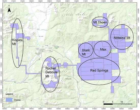
Figure 10. Jaxon’s seven projects on the Hazelton property near Smithers, BC.
Historical Works
Limited historical work has been carried out at the Kispiox project area with only one MINFILE on record, the “Date showing”. The Date showing is located on the southeast flank of Kispiox Mountain, 19 kilometres northwest of Hazelton. The area is underlain by sedimentary rocks of Late Jurassic Bowser Lake Group, intruded by a small granodiorite body of the Late Cretaceous Bulkley intrusions. Noranda Exploration carried out exploration activities on the Date showing area owing to anomalous molybdenum contents in silt samples and trace chalcopyrite observed in the field. Geological and geochemical surveys on the Date showing area were conducted in 1981 and 1983. 195 soil samples and six rock samples were collected and analyzed in 1981, and 18 rock samples were collected and assayed in 1983. Anomalous Au, Ag, Cu, Mo, Pb and Zn were found in various rock and soil samples. Due to the rugged nature of the terrain, the exploration work was limited in extent (P. McCarter, 1981 and Delbert Myers, 1983). There has been no trenching or drilling at the Kispiox area.
Geology
The Kispiox project is underlain by a series of sedimentary strata of the Late Jurassic Bowser Lake Group and Lower Cretaceous Kitsuns Creek Formation of Skeena Group intruded by numerous Late Cretaceous porphyritic intrusions of Bulkley Plutonic Suite.
Mineralization
The associated quartz-sulfides veins are centered on the area most abundant with intrusive rocks, and the veins are most prevalent along the margins of the intrusions and sheared contact zones (P. McCarter, 1981). A great amount of stibnite was observed in the veins, and trace amount of very fine-grained chalcopyrite and molybdenite appear within and adjacent to the veins. The sulfides are mostly fine-grained and disseminated in the veins. Pyrite is common in the quartz veins, and as fracture coating in the hornfels.
Taking into consideration the widespread rusty pyritic zone, intrusive dykes and plugs, mineralized quartz veins and anomalous Cu, Mo and Sb rock geochemical values, it is evident a porphyry-epithermal Sb-Cu-Mo system exists at the Kispiox project.
Rock and Soil Sampling and Analytical Procedures
All samples described in the news release were collected by the Company’s Qualified Professional Geologists. Chip and prospecting samples were collected in the field by experienced, professional geological staff who selected hand samples from outcrop or chip samples. The samples were numbered, described and located in the field for follow-up. Numbered rock sample tags were placed inside each bag, then securely closed for transport to the Company’s secure cold storage locked facility in Smithers, B.C. MSALABS of Langley, B.C. received the rice bag shipments after secure transport from Smithers. Samples were prepared by crushing, grinding and pulverizing to a pulp with barren material washing between each sample at the crush and pulverizing stages. Then 20 g of pulp was used for the ICP-230 for 34 elements or IMS-231 for 48 elements, FAS-111 fire assay for gold with ICP-ES finish and MET-440 for ore grade samples. Laboratory standards and QA – QC are monitored by the Company.
Soil samples were taken randomly among the mineralization zones. Approximately 200 g to 300 g of soil was sampled at a depth of approximately 25-30 cm from surface. Soil sampling primarily targeted the B horizon where appropriate, and samples were collected in labelled craft paper bags. Soil samples were analyzed via PXRF (Portable X-Ray Fluorescence Analyzer) for Cu, Pb, Zn, Ag, Mo, Sb and W.
All work was conducted by the Company’s team of qualified geologists.
Qualified Person
Yingting (Tony) Guo, P.Geo., President and Chief Geologist of Jaxon Mining Inc., a Qualified Person as defined by National Instrument 43-101, has reviewed and prepared the scientific and technical information and verified the data supporting such scientific and technical information contained in this news release.
About Jaxon Mining Inc.
Rich in large-scale geological targets/assets, Jaxon has seven porphyry system targets on its 100% controlled Hazelton property, an interconnected network of concessions spanning 700 km2 in the Skeena Arch in northwest British Columbia, Canada. The Skeena Arch is an exceptionally orogenic and metallogenic setting, geochronologically suitable to host preserved porphyries.
Jaxon pursues the discoveries of deeper, under cover, commercial scale and grade Cu, Au, Ag, polymetallic porphyry epithermal systems associated with distal mineralized, propylitically altered zones nearer to surface. Jaxon’s team is made up of experienced model-driven explorationists. Geochemical, geophysical and structural data is collected and integrated to generate 3D models to assist in the visualization and projection of the location of targeted porphyry systems.
Netalzul Mt is Jaxon’s most advanced target, the priority of seven identified porphyry epithermal system targets at Hazelton. Red Springs is the second target being prepared for drill testing. The five other targets are in various advancing stages of exploration.
ON BEHALF OF THE BOARD OF DIRECTORS
JAXON MINING INC.
“John King Burns”
John King Burns, Chairman
For more information please contact:
Investor Relations
Kaye Wynn Consulting
T: 604-558-2630
TF: 1-888-280-8128
E: info@kayewynn.com
